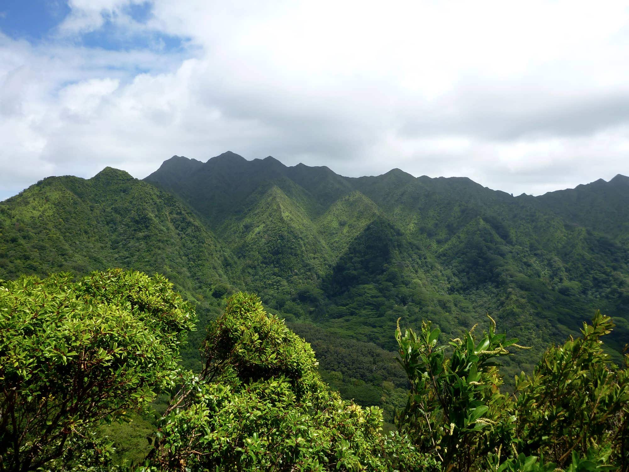
Oʻahu’s hikes run from a paved 1.6-mile family walk up Diamond Head to the 4,026-foot climb to Mt. Kaʻala, the island’s highest point. We picked 15 and grouped them by difficulty, five easy, five intermediate, five hard, with a map of every trailhead at the top.
The easy five fit a morning before the beach, and Makapuʻu Lighthouse stays paved the whole 2 miles. The hard five want a full day and shoes you don’t mind trashing, since Mānoa Falls runs muddy long after the last rain. Every hike here lists its trailhead, distance, driving directions, and a food stop nearby.
Table of contents
Related guides: Most people coming to Hawaiʻi visit multiple islands to make the most of the long trip needed to get here. If that is you and you like to hike, here are our hiking guides for the other islands.
On Oʻahu itself, many of these trails end at a waterfall. See our companion guide to Oʻahu waterfall hikes for the ones worth the walk.
Map
We show the trailheads of all 15 hikes discussed here on the map below. Keep reading for descriptions, directions and specific tips for each of the hikes.
5 Easy hikes
What do we mean by an “easy” hike? Mellow and doable for the everyday person and for families with kids.
Some of the best bang-for-buck hikes on Oʻahu fall in this group, like the Makapuʻu Lighthouse Trail and the Lanikai Pillbox: short, open to all abilities, with views that rival any advanced trail. Our 5 favorite easy hikes are:
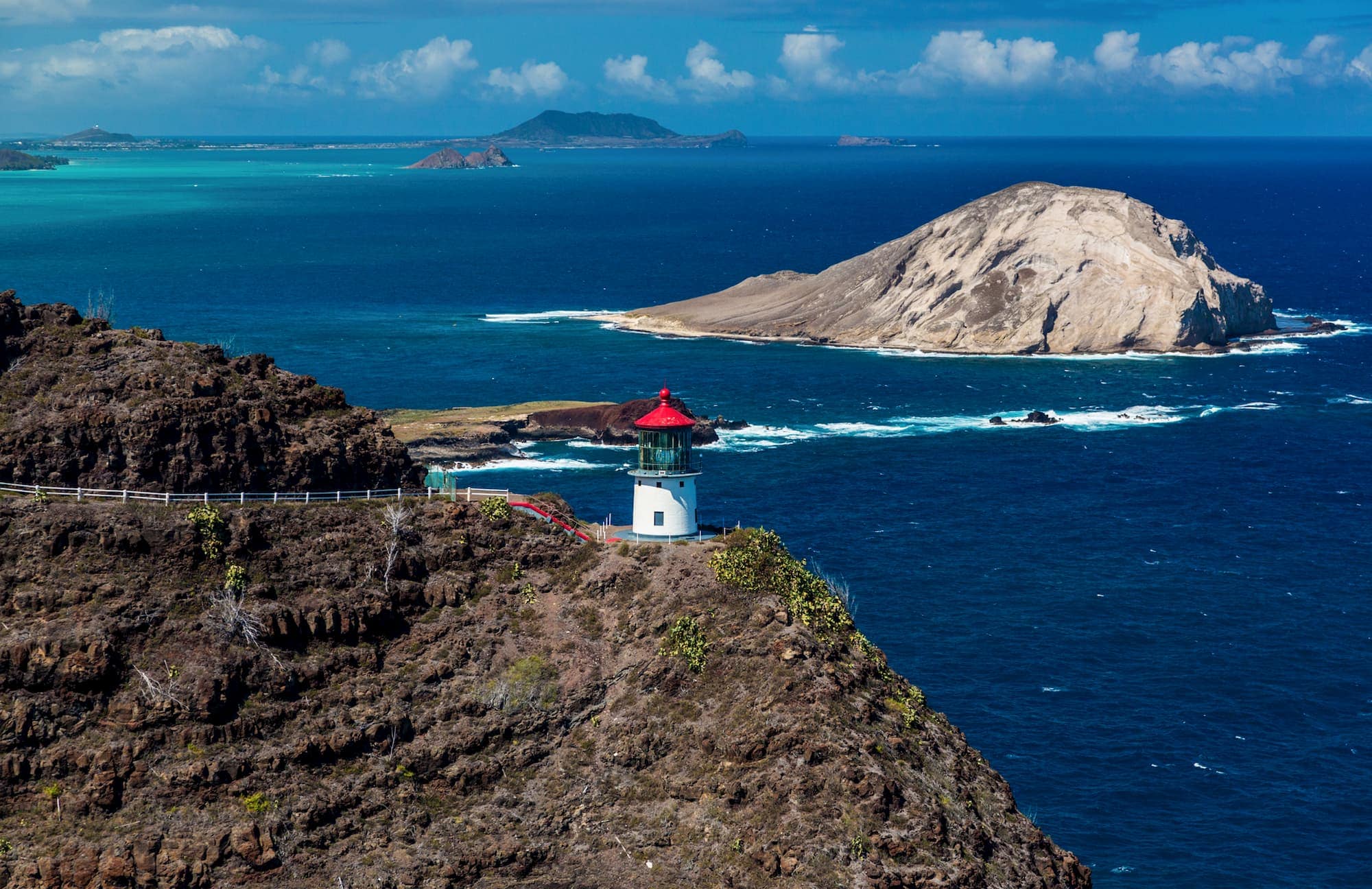
Makapuʻu Lighthouse Trail (2.0 miles)
Description: The paved surface and gentle grade make this one manageable with kids. It’s a mellow climb to the Makapuʻu Lighthouse and an overlook of the southeast part of the island, one of the best bang-for-buck hikes in terms of its accessibility and payoff. On clear days, you can see the islands of Molokaʻi, Lānaʻi, and Maui in the distance.
Why we like this hike: For big coastal views from an easy paved trail out to a cliffside lighthouse.
Directions: Pass through Hawaiʻi Kai going east on the Kalanianaʻole Highway and park at the Kaiwi State Scenic Shoreline parking lot.
Local grinds: Head back into Hawaiʻi Kai for a snack, drinks, and harbor views at Liko’s Tap & Table.
Read more: on the DNLR website.
Lanikai Pillbox (1.8 miles)
Description: Also known as the Kaiwa Ridge Trail, the Pillbox hike gets its name from the leftover army bunkers that sit atop the hillside. The short but sweet trail gives you an overlook of Lanikai beach, Kailua beach, Waimānalo beach, and the Koʻolau coast.

Directions: Park in the Lanikai neighborhood (follow parking signs, as it is strictly enforced) and find the trailhead across from the Mid Pacific Country Club on Kaelepulu Drive.
Local grinds: Pop over to Lanikai Brewery after the hike for a local beer and a bite from one of its rotating food trucks.
Read more: on the Alltrails website.
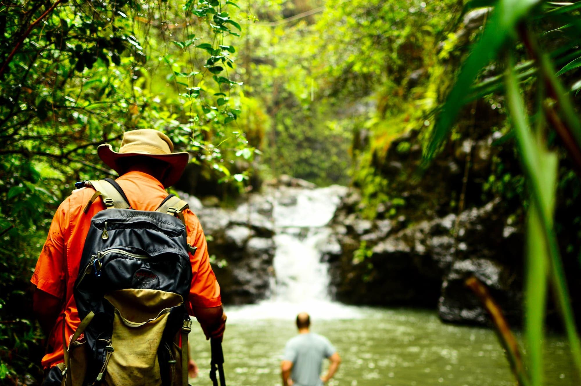
Mānoa Falls Trail (1.7 miles)
Description: An easy out and back trail that ends at the 150-foot Mānoa Falls waterfall in the heart of Mānoa Valley.
Directions: The trailhead sits at the end of Mānoa Road adjacent to the Lyon Arboretum. Expect to pay around $7 per vehicle at the private lot.
Local grinds: Check out Chef Jon Matsubara’s restaurant, Feast, in Mānoa Valley featuring Hawaiian-style burgers and sandwiches.
Good to know: The trail runs muddy after rain, so wear shoes with grip.
Read more: on the Alltrails website.

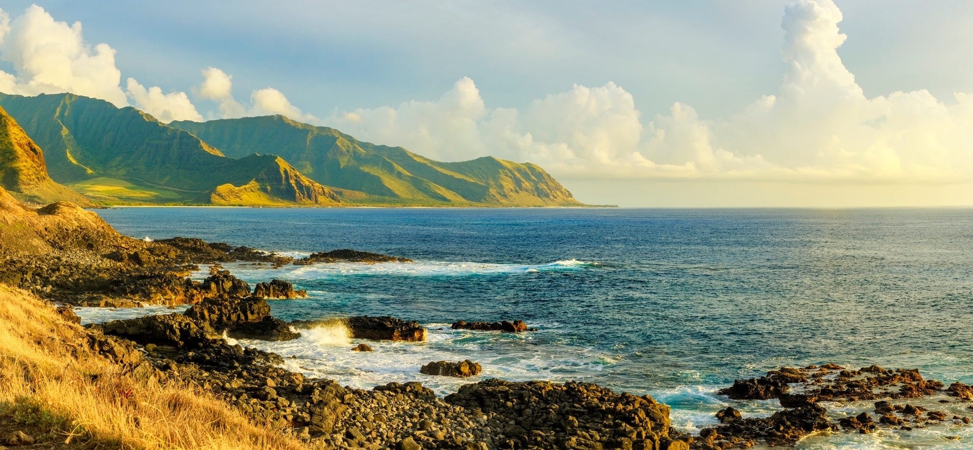
Kaʻena Point Trail (3.5 miles)
Description: This trail follows an old dirt road along the rocky coast. It leads to a remote, protected seabird sanctuary and provides great views of the Waiʻanae Mountains. Along the way, there are places to hang out, fish, and picnic. Whales are often sighted (Nov-March) as well as Hawaiian monk seals.
Why we like this hike: For wide ocean views and steady wildlife along an exposed coast: Hawaiian monk seals, plus whales from November to March.
Directions: You can access Kaʻena Point from the west side (Yokohama Beach) or the end of Farrington Highway on the North Shore.
Local grinds: Pop into Haleʻiwa Town and try the famous shrimp truck, Giovanni’s.
Read more: on the DNLR website.
Waimea Valley (1.9 miles)
Description: This shaded, paved walk takes you through a curated, outdoor botanical garden in Waimea Valley, ending at a 45-foot waterfall where you can swim (lifeguards on duty, lifejackets provided).
Why we like this hike: A well-maintained botanical trail ending at a 45-foot waterfall with a swimming and wading pool.
Directions: Waimea Valley sits on the North Shore, across from Waimea Bay. General admission is $26 for adults, with lower kamaʻāina, military, senior, and youth rates.
Local grinds: Stay inside Waimea Valley for a local plate lunch or burger at the café.
Read more: on the Waimea Valley website.
5 Intermediate hikes
An “intermediate hike” has some real challenges, so you should be in decent athletic shape and have some hiking experience before you start. A little more effort buys a better vantage point.
These five range from a classic, Diamond Head, to waterfall and ridge hikes. Our 5 favorite intermediate hikes are:
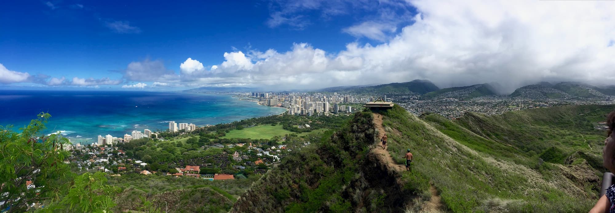
Diamond Head / Lēʻahi (1.6 miles)
Description: This popular, heavily trafficked route goes to the top of Diamond Head on a paved road. Near the top, stair climbing is required. The payoff is sweeping views of the Koʻolau Range, the south shore, and a clear overlook of Waikīkī and Honolulu. Though it’s paved and often completed by kids and families, the end is a steep climb and the top is warm with no shade.
Why we like this hike: For the wide views over Waikīkī beach and Honolulu from the crater rim.
Directions: The trailhead sits inside Diamond Head State Monument. Non-residents need an advance online reservation (gostateparks.hawaii.gov) and pay $5 per person plus $10 per vehicle to park. Hawaiʻi residents enter free and skip the reservation.
Local grinds: After, head to the Rainbow Drive in on Kapahulu Avenue for a local plate lunch.
Read more: about the summit trail on the DNLR website or see our complete Diamond Head visitor guide here.
Maunawili Falls (2.4 miles)
Trailhead status: The original Maunawili Falls trailhead on Maunawili Road stayed closed after the 2021 management and improvement project. Reach the falls on the longer, more strenuous Maunawili Demonstration Trail from Pali Highway instead.
Description: This hike winds its way through the Windward side jungles to a small waterfall with a swimming pool. It’s usually wet and muddy, so dress for it. Wear a bathing suit to swim at the falls.
Why we like this hike: Because you get to take a dip in a secluded swimming hole at the bottom of a small waterfall.
Directions: The trail begins in a residential neighborhood in Maunawili Valley at the end of Maunawili Road.
Local grinds: Cruise down into Kailua for a dip in the ocean and some seaside appetizers at Buzz’s.
Read more: on the Alltrails website.
Kuliʻouʻou Ridge Trail (4 miles)
Description: This trail climbs 1,600 feet via switchbacks to a ridge overlooking Waimānalo and the Windward side. Usually dry, the landscape offers Ironwood forests and lots of shade. The views at the end open up over Waimānalo and the Windward coast. Many locals use this as a trail run.
Why we like this hike: Because it is a rainforest trek through the heart of Oʻahu with expansive views of the island’s western half.
Directions: The trailhead sits at the end of Kalaau Place just west of Hawaiʻi Kai.
Local grinds: Refresh after with some local Vietnamese cuisine at the Ba-Le Sandwich shop in Hawaiʻi Kai.
Read more: on the Alltrails website.
Ehukai Pillboxes (2.1 miles)
Description: The trail is short but steep, gaining almost 700 feet in about a mile. From the two pillboxes, or old war bunkers, you get a great view of the North Shore as well as the Banzai Pipeline and Sunset Beach surf breaks.
Directions: The trailhead sits adjacent to the Sunset Beach Elementary School, across from Ehukai Beach park.
Local grinds: After the hike, head to Pupukea Grill across from Shark’s Cove for a local poke bowl.
Read more: on the Alltrails website.
Waimano Falls (2.8 miles)
Description: This trail is unique in that it starts at the top of a ridge and you hike down to the waterfall, which has deep pools and a rope swing. The return is where you’ll work your legs, climbing back up the steep hill.
Why we like this hike: Because it is a challenging hike to a quiet waterfall and several swimming holes.
Directions: The trail begins at the end of Komo Mai Drive above Pacific Palisades.
Local grinds: Cruise down to Pearl Harbor for a big meal and local beer at Restaurant 604. Its second-floor, open-aired dining area overlooks Pearl Harbor.
Read more: on the Alltrails website.
5 Difficult hikes
These five run longer and climb more, most of a day on the trail. “Difficult” means you should be in above-average athletic shape, have previous hiking experience, and be ready to spend most of the day out.
Though the distances are not extremely long, the elevation gain and trail conditions (mud, rocks) can make things challenging. Those willing will be treated to some of Oʻahu’s most rugged backcountry, including the island’s highest peak, Mt. Kaʻala.
Our 5 favorite difficult hikes are:
Mt Olympus (5.2 miles)
Description: This big, demanding hike climbs more than 2,000 vertical feet to reach the top of Mt. Olympus and its Mānoa Valley views. Often wet and slippery, ropes are found on the trail to assist in climbing and descending.
Directions: Start at the Waahila Ridge State Recreation Area and take the Waahila Ridge Trail. When the trail splits, stay right towards the top.
Local grinds: Head down into Kaimuki for some ribs at the Surfing Pig.
Read more: on the Alltrails website.
Olomana (4.4 miles)
Description: This steep trail gains almost 2,000 feet on your way up to the first of three peaks that rise above the Windward side. The views from the first two peaks offer the best vantage points of the Koʻolau range and the coast. The first two peaks are relatively safe. Peak three is dangerous, don’t attempt it.
Why we like this hike: You get to summit a trio of steep peaks for the payoff of open Koʻolau and coastline views.
Directions: There is no parking at the trailhead for this hike. Park on Auloa Street (pay attention to parking signs) and then walk down Loop Drive. The trailhead is past the entrance to the Royal Hawaiian Golf Club.
Local grinds: After this leg burning hike, kick back at Kalapawai Grill in Kailua for sandwiches and local plates.
Warning: The part of the Olomana trail from the first to the third peak is probably the most dangerous trail on Oʻahu, with a rescue there roughly once a week on average. Only progress past the first peak if you are a confident and experienced hiker and use proper judgement at all times.
Read more: on the Alltrails website.

Koko Head (1.8 miles)
Description: Don’t let the distance fool you. This hike goes straight up, gaining nearly 1,000 feet in less than a mile, and the trail is composed of old railway planks. Very popular with locals as an evening workout, avoid the heat of the day as there is no shade.
Directions: The trailhead sits in Koko Head District Park. The lot fills fast on weekend mornings, so arrive early or come back in the late afternoon. The park is closed 11 p.m. to 4 a.m. (see hours here), so don’t plan on a pre-dawn start.
Local grinds: Completion of this hike deserves a beer (or two). Head down the street to Kona Brewery by the marina for a recovery meal.
Read more: on the Alltrails website.

Mt. Kaʻala (7 miles)
Description: This trail accesses the highest point on Oʻahu, Mt. Kaʻala (4,026 feet). This hike requires a steep climb up the dry hillsides of Waiʻanae and gains more than 3,500 feet. The views along the way are wide open, though there’s no true summit viewpoint. At the top is a cloud forest, accessible via boardwalk, that contains a high concentration of native plants, and some of the only ʻōhiʻa trees left on Oʻahu.
Directions: The trailhead sits on the west side of Oʻahu, at the end of Waiʻanae Valley Road.
Local grinds: Stop by Kahumana Organic Farms for a locally-sourced lunch at its café.
Read more: on the Alltrails website.
Wiliwilinui Trail (4.5 miles)
Description: This ridge hike is not super long, but it’s steep, especially at the end, climbing more than a thousand feet to the top of the Koʻolau Mountain Range. The view is wide open, an overlook of the entire Windward side.
Directions: The trailhead sits at the end of Okoa Street, inside the gated Waiʻalae Iki community. Stop at the guard gate for a parking pass. The passes are limited and run out, and once they do you park outside the gate and walk in. Trail access runs sunrise to sunset.
Local grinds: Pop down into Kaimuki for sandwiches at Kaimuki Superette.
Read more: on the Alltrails website.
Local Youtuber Sean Kaleponi made a very informative video about hiking the Wiliwilinui ridge trail. If you like his style be sure to follow him on Youtube and Instagram.
![Epic Hiking Trail in Oahu, Hawaii│Wiliwilinui Ridge [FULL GUIDE] Best Trail](https://loveoahu.org/wp-content/plugins/wp-youtube-lyte/lyteCache.php?origThumbUrl=https%3A%2F%2Fi.ytimg.com%2Fvi%2F72zygZpHQ-A%2F0.jpg)
Hiking and safety tips
We rate these in general terms. Know your own limits before you start. Please be respectful of local residents when hiking. Don’t trespass, don’t park illegally, and don’t leave valuables in your car. Bring plenty of water and snacks, wear proper footwear, and watch the weather, since conditions change fast. Always pack a rain jacket.
The Haʻikū Stairs (Stairway to Heaven): closed and being removed
When researching the best and most popular hikes on Oʻahu you are bound to find mention of the Stairway to Heaven hike, a steep trail of 3,922 steps running up Oʻahu’s Koʻolau range.
The stairs have been officially closed to the public since 1987, and there’s no legal way to hike them. In April 2024 the City and County of Honolulu began removing the structure, a roughly $2.58 million project, so the stairs are being taken down rather than reopened. If you go, expect a posted no-trespassing site and a possible citation from Honolulu Police.
For those reasons we ask that you leave this one off your list and pick one of the 15 hikes above instead.